
NW Tyler – NW Lyman to NW Paramore Project Design and Planning Underway!
Project Schedule Benchmarks
- 2020 Project Planning and Design
- 2021 Final Design and Utilities Relocation
- 2022 Phase I Construction – NW Tyler – NW Lyman to NW Beverly
- 2025 Phase II Construction – NW Tyler – NW Beverly to NW Paramore
Attend a Virtual Meeting of the NW Tyler – NW Lyman to Paramore. Get an inside look at the design teams thinking process that lead to the concept the City has chosen.
Contact Information
Brian Austin P.E., SBB Project Designer – 215-8630, brian.austin@sbbeng.com
David Bevens, Public Works, 213-4538, dlbevens@topeka.org
Note: Please provide us your name, address, including zip code, and phone number when you contact us. See the different ways you can receive information about the project at the bottom of the page under “Public Outreach”.
Project Background
The Tyler Street Project has been in the works for quite some time. The City of Topeka Planning Department worked with the North Topeka West Neighborhood Improvement Association and other interested groups and individuals within the neighborhood over a 24-month period to develop the comprehensive North Topeka West Neighborhood Plan.
The NTW neighborhood boundaries are N. Topeka Boulevard to the east, 75 Highway to the west, 24 Highway to the north and the Kansas River to the south. Soon after its completion, the Topeka City Council adopted the NTW Neighborhood Plan on February 26, 2016.
In general, one of the goals of the NTW Neighborhood Plan is to, “Provide infrastructure and improvements to the North Topeka West neighborhood that demonstrates vitality and commitment to continued improvements in the quality of life of the residents.
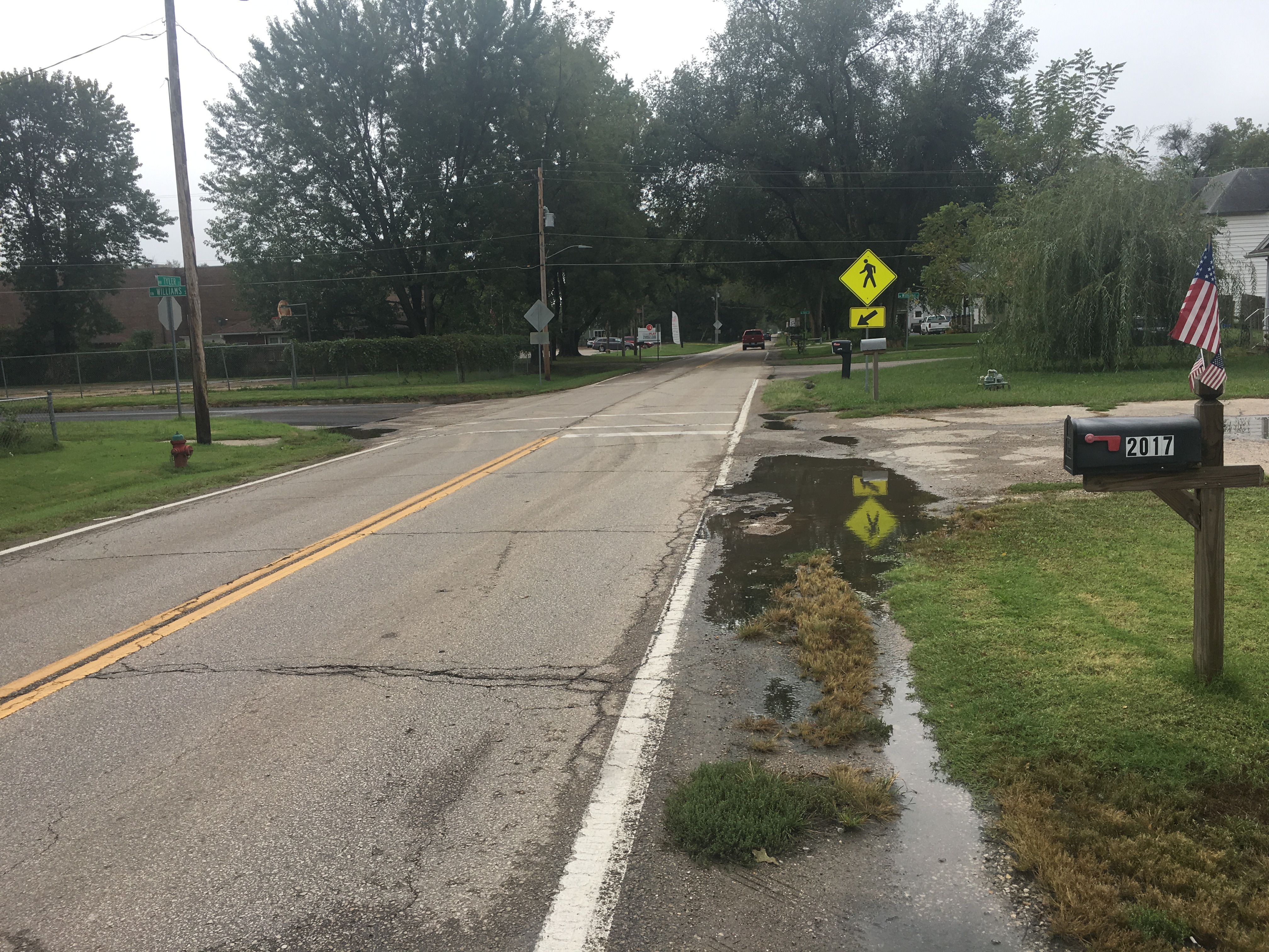
More specific, the plan calls out the need to improve NW Tyler from NW Lyman Road south to NW Paramore and designates it as “a high priority of the neighborhood and should be implemented as soon as funding is secured.”
The NTW Plan also includes the following Guiding Principles:
- Create a pedestrian corridor using Complete Streets principles
- Capacity to support future development
- Make parks and trails more visible, accessible and kid friendly
- Eliminate ditches and add curb and gutter
- Create pedestrian streetscapes and connect to amenities
- Reduce truck traffic
- Lower vehicle speeds
- Use appropriate street width
Three Design Concepts Considered
SBB Engineering, Inc., the design firm chosen by the City of Topeka to design the Tyler Street Project, developed three design concepts for the City to consider. All three concepts followed Complete Streets guidelines. All three included two 5’ foot wide and ADA compliant sidewalks and a 10-foot multi-use path between Tyler and Soldier Creek Trail across City-owned property.
Bikeways were not included in the concepts because of parallel routes on each side of Tyler – Old Soldier Creek Trail NW Polk. With under 4000 vehicles per day on Tyler, experienced and confident riders can use the street and less experienced and non-confident riders can use the sidewalks.
The three concepts considered are as follows:
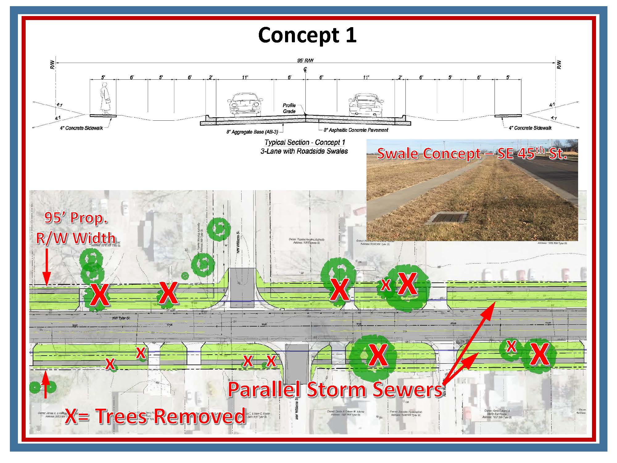
Concept 1: A three-lane section, including a center turn lane, storm water swales and 5’ wide sidewalks, one on each side of the street, and underground storm water storage/infiltration chambers.
Advantages
- Low environmental impact design
- Swales allow for more green space between street and sidewalks
Disadvantages
- Swales may appear as ditches, which is contrary to the neighborhood plan.
- The design would require 10 feet more of right of way on both sides of the street, therefore more Right-of-Way acquisition. The additional width would require removal of more trees between the street and the homes/businesses.
- More area stormwater inlets would be required and a parallel storm sewer system would be required, one on each side of the street, which would cost more than a typical storm water piping system. Also, the Garfield Wetlands, located downstream from the neighborhood, will filter out impurities and enhance storm water quality of water that flows from the neighborhood.
- A 17-year-old water line on the east side of the street would have to be moved. Water lines usually last at least 50 years or more.
Because of higher costs associated with Right-of-Way acquisitions and utility relocations, the removal of trees, and in conflict with the neighborhood plan, Concept 1 was eliminated.
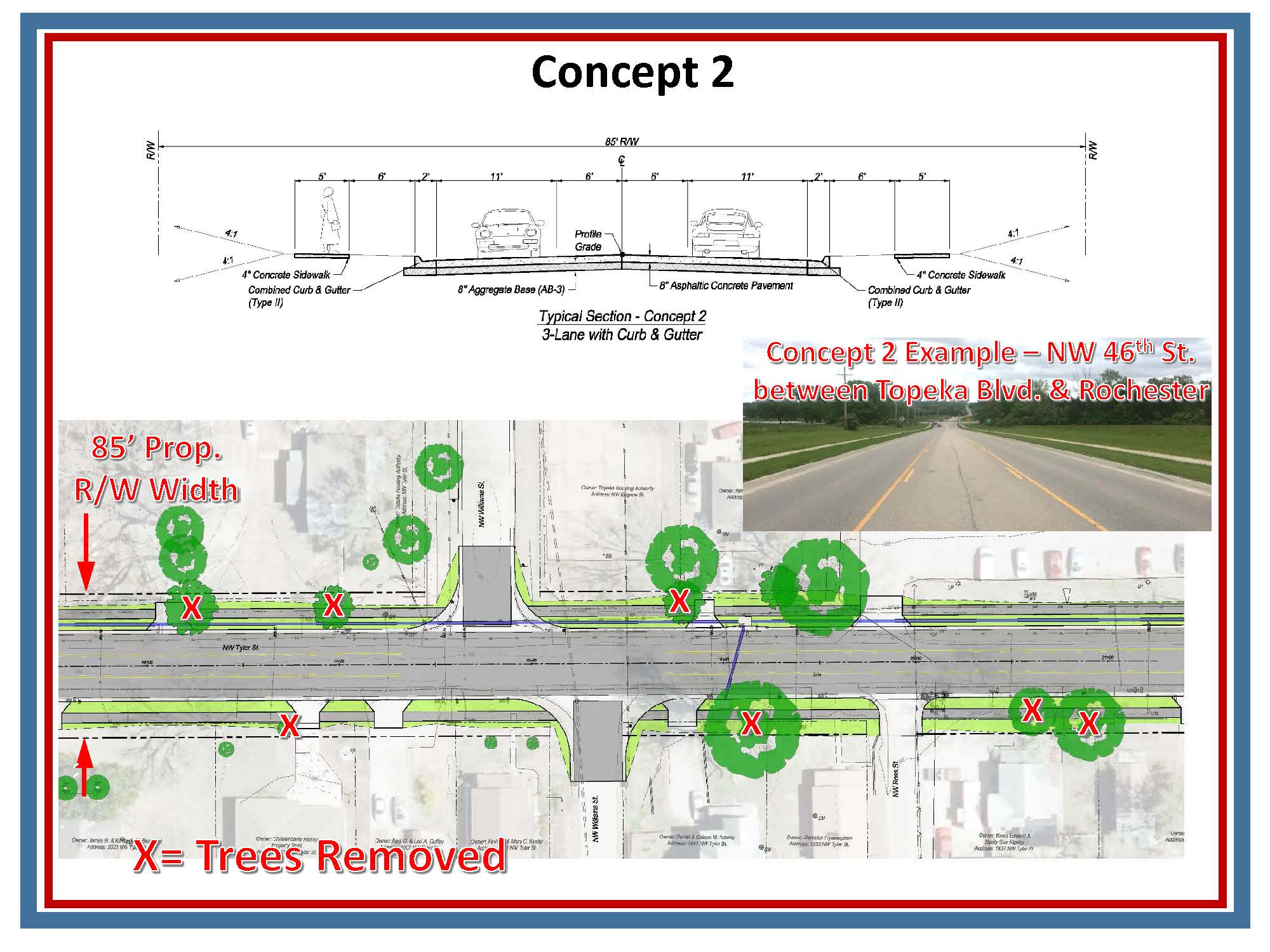
Concept 2: A standard three-lane section, including a center turn lane, curb and gutter, typical storm water pipes, and a 5’-wide sidewalk on both sides of the street.
Disadvantages
- May result in higher vehicle speeds over a 2-lane option
- More impervious surface, which would result in more rainwater runoff
- More right of way required, which would require more utility relocation and tree removals.
- Traffic volumes and crash data don’t show significant benefit from three lanes. SBB analyzed several factors in determining if a 3-lane section was necessary for safety and capacity. Although there were 14 crashes in 5 years, none that would have been prevented with a turn lane. Traffic counts showed just under 4000 vehicles per day (low volume). Common practice is to begin considering a third lane (turn lane) if there is a high frequency of drives AND 8000+ vehicles per day.
Because vehicle traffic and crash data didn’t show a third lane would significantly improve safety and traffic capacity, Concept 2 was eliminated.
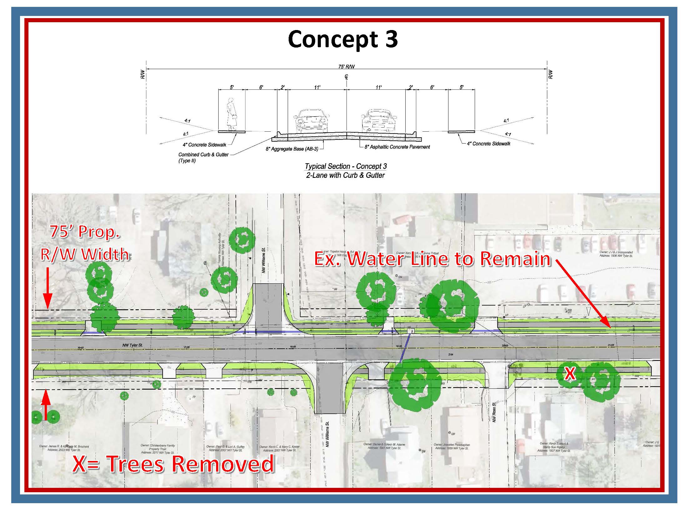
Concept 3: Standard 2-lane section with curb and gutters, storm sewer and 5’ sidewalks, one on each side of the street.
Advantages
- Allows the 17-year-old waterline to stay in place, which would be a cost savings.
- A $350,000 cost savings for not building a center turn lane.
- Drivers won’t feel as comfortable driving at high speeds on a 2-lane street compared to a 3-lane street, Likely resulting in lower vehicle speeds as desired in the neighborhood plan.
- Shorter crossing distance resulting in increased safety for pedestrians.
- Less Right-of-Way would need to be acquired and fewer trees removed.
- Less impervious area and therefore less rainwater runoff.
Based on the Advantages listed above, Concept 3 is considered the best option! The project design is being moving forward based on Concept 3. The utility design portion of the preliminary design is expected to be completed by mid-September to allow the utility companies’ time to design their infrastructure relocation projects.
Public Outreach
City staff are committed to engaging with our neighbors by creating opportunities to share and receive vital information about City projects. Engineering is one leg of a project and public engagement is the other. In an effort to foster these interactions, the City is taking the following actions:
Public Meetings – There will be at least three neighborhood-wide public meetings where design engineers will make a presentation, receive questions and comments, and respond back directly in-person or through FAQ’s, email, phone, or mail. The general timing of public meetings are:
1st Public Meeting – Now! See the Virtual Public Meeting Presentation video clip above about the pre-design concepts considered and the one selected for design. Note: This meeting is a “virtual” format because of the COVID-19 Pandemic. Future meeting formats will be determined as the time for them approaches.
2nd Public Meeting – Spring 2021 once the final Design is complete
3rd Public Meeting – Spring 2022 once the project has been awarded to a contractor
Social Media Postings – The City uses Nextdoor, Facebook and Twitter to get information out. If you are not already using social media, please consider joining them.
Project-Specific Email Address – Contact us at TylerProject@Topeka.org. We will put your email address on an email list for the Tyler Project and periodically send updates.
Printed Material – You can request and receive hardcopies of project information by reaching out to us through the options above. Information will be mailed or dropped off.